Authors Note: Do you want to see what the proposed stadium site might look like in the future without a “Convadium”? Check out the recently released East Village South Draft Focus Plan. It is the culmination of community workshops held earlier in the year and the efforts of some of the City’s most prominent architects. The effort was sponsored by the American Institute of Architects – San Diego and Citizens for Century III (C-3). Unlike the Spanos plan, development won’t tap $1 billion plus in public funds and property but is designed to generate public funds, high paying jobs, and economic activity.
It also won’t result in the large-scale displacement of homeless from the East Village nor have the negative traffic, noise, automobile pollution, and view blockage on the adjacent neighborhoods. Contrary to the claims of stadium proponents, the Focus Plan will happen – is happening – faster than a Convadium. Unlike a mega-public project requiring rezoning, land assemblage, eminent domain, demolition of historic resources, large-scale environmental clean-up, removal of the MTS bus yards, spanning earthquake faults, bond issuance, and possibly years of litigation, the East Village Focus Plan is already happening, will near completion and create benefits much sooner than a Convadium. The projects are privately funded, except for affordable housing funds, and is happening on a lot by lot, block by block basis, not having to wait for all hurdles to be cleared before construction can commence.
By Bill Adams / UrbDeZine
The following text and images comprise the East Village Draft Focus Plan released on July 30, 2016, including subsequent minor corrections and additions made by its authors. It has been reconstituted here from the PDF original version to enable web and mobile viewing The original version may be downloaded from this PDF link(warning: downloading PDF may require high capacity broadband connection).
 With the adoption of the Downtown Community Plan in 2006 it was determined that each designated downtown neighborhood would create a finer-grain plan, in the form of a Focus Plan, to make certain future development would honor the Community Plan and enhance the unique personality of each district. For several reasons, including the economic downturn and the elimination of CCDC, the Focus Plans for the four East Village quadrants were not completed.
 In fall of 2015 a group of East Village residents, business, academic and community leaders and land owners discussed the need for a Focus Plan for the southeast quadrant as new development started rapidly taking shape throughout East Village. At this point in the community’s (and downtown’s) revitalization, several things became clear:
- Due to successful residential development throughout the late 1990’s and early 2000’s, 34,550(1) people now call downtown home. This population is projected to grow exponentially (more than 108% from 2012 – 2050)(2). Open space, parks and civic amenities have not kept pace with a growing population.
- Home to City College, East Village added a significant number of educational institutions from 2005 – 2015 including elementary, high school, university and post-graduate schools and programs. At the same time City College has been aggressively expanding its campus and offerings.
- Job growth has not kept pace with residential development. Close to 70% of downtown residents(3) commute from downtown to regional employment centers.
- The success of Petco Ballpark as a catalyst for growth has been realized. Development has filled in and around the Ballpark and is now aggressively heading east, transforming the less developed parts of East Village.
- At the same time Barrio Logan to the south had seen significant redevelopment. Now is the optimal time to link underserved neighborhoods to the south to the urban core.
East Village is at a cross roads. If development follows the approved Community Plan and continues on its current course, East Village has the opportunity to be realized as a true urban neighborhood. A neighborhood in which people don’t just reside, but can walk to work and sustains a rich offering of entertainment, shopping, dining and recreation.
As the Focus Plan was being prepared two overarching issues were recognized.
1. Public Participation
We understand that any ambitious plan or vision must include a broad coalition of participation from both the public and private sectors. For example, the growth of the bio-tech and bio-pharmaceutical industries in San Diego is a direct result of then Mayor Pete Wilson’s leadership in using city land to incubate research-based businesses that emanated from UCSD(4). It took private business, venture capital, real estate development, public investment and leadership for this success to be realized.
For many reasons including demographic and social trends, concerns about creating sustainable communities, and generational preferences, the frontiers of the new economy are growing in the urban fabric of cities. A lot of investment has been already made in revitalizing downtown San Diego. We suggest that for downtown to achieve the jobs-housing balance originally envisioned, progress will require all stakeholders at the table.
We hope that by providing this Focus Plan, we can add further fuel to the conversation.
2. Timing
In the workshops, as well as one-on-one meetings, people have voiced their concerns about whether something like an innovation district could be realized without a major San Diego university or tech-oriented business making a significant commitment to anchor the district. They are concerned, and rightly so, that without investment on the part of the city or a major institution the full potential of the neighborhood, and indeed the downtown area will never occur.
We believe that between development already occurring, especially in IDEA District, the number of business start-ups in downtown, and the demographic make-up of downtown residents, that with the right focus and commitment, an emerging jobs-cluster can be realized more quickly than anyone anticipates. To put it into perspective, with the right incentives and investment downtown’s population grew 97% since the year 2000.(5)
Last year, the Downtown San Diego Partnership commissioned UC San Diego Extension to conduct demographic and economic study of downtown San Diego. In the study’s conclusion it states that “Downtown San Diego is one of the few major cities in America, and California, where there is still the potential to further expand a dynamic and a uniquely inclusive innovation economy.” It specifically highlights the “Available, developable land downtown, particularly in the East Village…contiguous to a number of diverse neighborhoods with developable land, including Barrio Logan, Golden Hill and the Diamond District”(6) as one of four primary reasons downtown is ripe for this effort.
The study in its entirety can be found at: http://www.downtownsandiego.org/wp-content/uploads/2016/05/DSDP-Demographic-Study-2016.pdf.

OVERVIEW
A. Focus Plan Goal
This plan is a neighborhood-centric overlay that is intended to encourage a unique identity for the East Village South neighborhood.
 It is intended as a framework for discussion on the continuing development of East village.
The implementation of this Focus Plan will enhance the general quality of life and give guidance on critical issues, such as connecting to adjacent communities and effectively using the bus yard/ tailgate parking lot sites.
B. Consistency with Master Plan
This Focus Plan is designed to be compatible with and provide implementation guidance for the Downtown Community Plan. The recommendations of the Focus Plan are consistent with the recently adopted Downtown Mobility Plan.
C. Adoption Process
The plan was created by a diverse group of community activists working with the larger East Village community through a series of well documented public workshops (see reports in appendix). Volunteer architects and planners refined the community input into this Focus Plan outline. This document is no more than a framework for implementing the community vision and will need to be vetted and completed by professional planners at Civic San Diego through a public process. Like the other downtown Focus Plans, the final document will then need to be approved and formally adopted by the City Council.
VISION
An exciting vision of the East Village South neighborhood emerged from two public workshops involving more than 300 people.
Common themes:
- Diversity
- Connection
- Honor history (both structures and social history)
- Sustainable
- Equitable
- Open (as in open space)
Participants widely agreed that the following elements represent the vision for the plan:
- Make strong and vibrant connections to the Barrio and Sherman Heights. The 14th Street Promenade and freeway cover and street grid are “sacred cows” and must not be sacrificed.
- Address jobs. Connect the people currently living in East Village and downtown with the type of jobs they seek – high-paying jobs in the innovation, design and technology sectors. For example, an innovation district anchored by an academic complex which “Connects business to academic institutions. And, connects people to jobs.”
- The 14th Street Promenade Green Street is our “Main Street” and primary North/South connector. It should extend all the way to Chicano Park and thread northward through City College to Balboa Park.
- Build on the unique East Village Academic Armature already in place.
- Create a memorable and major public open space or series of open spaces to anchor an “innovation district.” Pocket parks and/or green spaces must punctuate the neighborhood.
- Create Freeway Cap Park and cover the freeway as per the Community Plan.
- The Focus Plan should be authentic and unique to East Village. “Embrace the urban lifestyle” and promote diversity.
- Respect fine grain development and the urban street grid. “More Wonder Bread type development.” This includes breaking down the existing super blocks by replacing missing streets.
- Create affordable housing and affordable small business places.
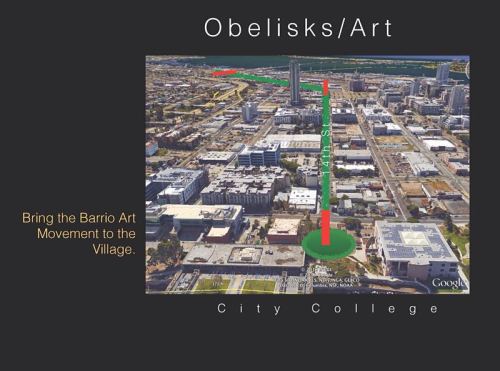
- Make a strong urban statement at the “knuckle” where 14th turns in to Logan Avenue (This could be an obelisk or major art piece authored by Barrio artists.)
- Find a way to embrace the homeless issue. Don’t separate Father Joe. Or push the homeless into adjacent neighborhoods.
- Reduce special event noise.
- More art throughout East Village.
- Celebrate the historic African American heritage of the area.
- Develop the area as a 24-hour neighborhood to include office, academic, commercial and residential uses.
- Partner with the military for high-tech training or related vocational training.
It was agreed that giant, monolithic buildings like a stadium are not conducive to this vision. These types of structures are at direct odds with the desire for connections, keeping the community “porous”, ensuring view corridors are intact and making the neighborhood livable and family-friendly.


GUIDING PRINCIPLES
The core of this plan builds on the public input above and includes the Six Guiding Principles:
1. Define a Unique Neighborhood
The goal is to make the neighborhood memorable and engaging. Distinct physical cues and design elements will give the community a unique identity and distinguish it from other downtown neighborhoods. These can be predictable, like paving patterns and building materials, or unexpected and idiosyncratic, like a neighborhood shrub or a mandated wainscot on utility infrastructure.
It is equally important to capitalize on the existing distinctive attributes of the area. East Village South has nine academic institutions with more anticipated in the near future. It is also home to many small start-up companies. This area, with its share of warehouse structures and developable blocks is recognized as ideal for attracting companies in the high-tech, design and development fields. To realize success it must be cultivated and supported by public action and planning directives. If entities are supported, a powerful and exciting dynamic could energize the entire downtown and region.
The goal is to make the neighborhood memorable and engaging. You need to know you are in East Village South without signage.
2. Leverage the Academic Vibe
One obvious and powerful idea is to build on and celebrate the Academic Vibe. Only East Village has nine academic institutions with more coming.

East Village is one of the major educational clusters in the region. From elementary schools to high schools, college and post graduate work, all can be found in East Village. The focus and approach of many of the curriculums is on the Arts, Design and Innovation and they complement, and are complemented by, the same activities in the neighborhood.
3. Encourage & Nurture Employment
Downtowns thrive when there is a robust and synergetic mix of job-generating uses, combined with residential, retail, public spaces, cultural attractions, great streets, etc. As stated in the introduction, the missing piece in downtown San Diego is the jobs engine. With the recent upsurge in entrepreneurial activity downtown, including 110 start-ups(7), now is the time to intentionally nurture and grow the next great San Diego companies. It was determined East Village South is the ideal location because land is available – much of it publicly-owned – and the innovation ecosystem in Upper East Village is starting to gain traction.
But matching the type of jobs to the resident profile most attracted to urban living, will be the real key. Currently downtown San Diego residents are educated (51% have a Bachelor or an advanced degree); they are mostly employed in management, business, science and the arts (55%) and earn an average income of $73,756. And, contrary to popular wisdom only 17% are single.(8)
Building on the robust education spine in East Village, the workshop participants indicated a strong desire to add additional higher education facilities in East Village South, and pair these idea creators with clean, high-paying technology companies that want to be near them. The job generation potential of combining these complementary users has been dramatically proven on the Torrey Pines Mesa, and in cities including Boston, Seattle, and San Francisco.
Furthermore, East Village is adjacent to some of San Diego’s most economically and environmentally disadvantaged communities. The absence of major university campuses south of San Diego State University further limits opportunity. Encouraging and nurturing high paying clean jobs, as well as the academic trajectory in East Village, holds promise for creating more opportunity for these communities. Moreover, high paying jobs associated with internet / mobile software technology are not limited to those with four year degrees. Many of these jobs are available to persons who have mastered code and other internet/mobile technology skills, either through informal apprenticeships or through interaction with other skilled persons. The combination of academia and high tech employers will create opportunity and boost incomes in adjacent communities without aggravating environmental problems in those communities.


4. Enhance Livability through Public Open Space
As neighborhoods become denser, generous open space becomes more critical to livability. East Village South will soon be one of downtown’s densest neighborhoods, but has only one mid-sized park. The 14th Street Promenade Green Street with its widened sidewalk and enhanced landscaping will serve not only as the major north/ south connector but also greatly contribute to the public realm.
As the workshop participants noted, public spaces should adapt to “temporal” scale and uses. This means that they can be deliberately changed to meet the needs of the community; a food truck haven turns into pop-up work space turns into playground turns into public art exhibition.
This plan identifies opportunities for the new major new open spaces desperately needed in this neighborhood.
5. Connect Neighborhoods
Enhancing and creating connections to surrounding neighborhoods is a top priority and the timing is right.
 The 14th Street Promenade, if extended, will play a central role in connecting Barrio Logan to City College through the East Village neighborhoods. It is highly desirable to continue the connection through San Diego High School and to Balboa Park. Island and “J” Streets promise to be compelling and walkable east/west connector streets, but are blocked from connecting to Sherman Heights by Interstate 5. The Downtown Community Plan identifies that location for a freeway lid. This cover is an opportunity to create additional park space as well as affordable housing.
As stated previously, large monolithic developments like a stadium creates walls rather than connections and are inconsistent with the principles of both the Focus Plan and the current Downtown Community Plan.
6. Preserve View Corridors
The views down the city streets to the bay and bridge give East Village a strong character. Walking along 13th Street, 14th Street, and 15th Street in the afternoon with the buildings in shadow and the Coronado Bridge alive in the afternoon light is one of the qualities most cherished in the community. These view corridors must be protected and enhanced if possible. The Focus Plan retains the 13th Street and 14th Street views and opens up 15th Street to an enhanced view of the bridge.
IMPLEMENTATION STRATEGIES
1. Define a Unique Neighborhood
The following ideas are suggestions that came out of the community workshops and were refined by the professional architectural/planning team. The participants wanted to include a set of simple, but distinct, requirements that would help to establish a unique physical identity and character for the community. Obviously, for that to happen, the section below differs from some of the design, lighting and signage standards that apply to downtown as a whole.
Architecture:
Village of Towers: Except for office towers, developers and their architects are encouraged to create improbably slender towers in this neighborhood. It might be a fragment of a larger building or a complete high rise. Contemporary design is encouraged.
“Superblocks” or single full-block developments by a single architect and developer are discouraged. While the Downtown Community Plan also discourages superblock development, they have become the norm in much of East Village.
Materials:
No reflective glass permitted below the third story. 40% of street level glass must be low-iron and non-reflective.
Color:
All buildings must be colored at least 80% cream white (apart from view glass) above the 7th story. Over time, this simple regulation will give the neighborhood a distinct visual identity — even from afar.
Public infrastructure like light poles and transformers should have a wainscot of colored cream white to a height of 4 feet above grade and can easily be repainted. Transformers would preferably by located underground, but should be similarly be painted cream white if they are street level.
Landscape:
The following items should be unique to the neighborhood and selected by landscape professionals and approved by the public.
- Paving in plazas and public areas that is memorable and different from the rest of downtown
- Unique trash cans and benches
- A neighborhood “Signature Shrub” that is encouraged in every development
Signage:
- Free-standing rooftop signs are permitted below 8 stories.
- No signage or logos is allowed above 8 stories.
- The curved portion of city curbs at intersections is allowed to be covered with ceramic tile advertising. Proceeds will be donated to the East Village Association.
Lighting:
- Use lighting as a way to further distinguish and differentiate East Village South from other downtown neighborhoods. A professional lighting designer should be retained to create a plan to make East Village South subtly unique at night.
- No neon stripes permitted.
- No digital billboards or moving images permitted except behind first story storefront
2. Leverage the Academic Vibe
The East Village is one of the largest educational clusters in our region — and the most academically diverse. Students can attend from elementary school through specialized post-graduate work.
At the north end of East Village is San Diego High School Educational Complex, located in a portion of Balboa Park for over 134 years. The school with an enrollment of 3,000 students is comprised of three schools; School of Business and Leadership, School of International Studies and School of Science and Technology.
To the south across Russ Boulevard is San Diego City College, with an enrollment of over 18,000 students. It is located on a campus that is continually expanding with new facilities and programs – over $500 million has been invested in the past five years. And with that expansion City College has physically become even more a part of East Village.
The Urban Discovery Academy Charter School opened in 2014. Located at 14th and F Streets has a focus on individual student support and project-based learning.
The NewSchool of Architecture & Design is located at Park Boulevard and F Street. NSAD has an enrollment of over 500 students in programs in Architecture, Construction Management, Interior Architecture, Product Design and Digital Media Arts. NewSchool’s architectural program, already one of the nation’s largest, will double its enrollment while adding new design-related programs.
Located at Park Boulevard and Island is the Thomas Jefferson School of Law. The school, with an enrollment of over 500 law students, moved to its new facility in East Village several years ago.
At 10th and J Streets is FIDM, the Fashion Institute of Design and Merchandising. FIDM offers programs in Fashion, Visual Arts, Interior Design and Entertainment.
At 10th and K Streets is the San Diego Global Knowledge University [SDGKU]. SDGKU offers undergraduate and graduate degrees in Global Management, International Management, Communication and Technology and a Doctor in Business Administration in Global Management.
An educational anchor at the south end of East Village is The Central Library, completed in 2013. A unique feature of the Central Library is the E3 Civic High School a public charter secondary school. The curriculum includes internships and offers two pre-professional programs; bio-medical health and digital media. Students graduate with both a high school diploma and a community college degree.
Academic Connectivity
These educational institutions are all located along an axis that connects them to each other, to Balboa Park, and the San Diego Bayfront – The John Nolen Parkway [Park Boulevard). This collection of educational institutions not only promotes collective support, but is reinforced by the surrounding context of innovative activity. Adding to this is the potential of a major university locating an institute focused on Innovation in East Village.


“Downtown San Diego is poised to be the next frontier of innovation because of the convergence of basic science and computer science….the reason is simple: Talent is what drives San Diego’s economy, and it always has…and now more than ever what these tech folks want is an urban environment where they can walk and bike to work, shops, restaurants and cultural amenities.”
San Diego Union-Tribune, op-ed. [April 22, 2016] Mary Walshok, Associate Vice Chancellor for Public programs at UCSD and Kris Michell, President and CEO of the Downtown San Diego Partnership
3. Encourage & Nurture Employment
Consistent with the goals of the Community Plan and the input from the community workshops, East Village South is envisioned as an engine for job creation, both for downtown and the region. Towards that end, the Focus Plan encourages:
- A mix of uses including Academic facilities, creative and tech office space, retail at the pedestrian level, a variety of residential products with a wide range of affordability, and hospitality.
- Large floor plates – appropriate for Academic and Tech office space – could also accommodate convention facilities.
- A variety of public gathering spaces that encourage residents of the area, and surrounding neighborhoods, to “collide” with one another (hence spur cross-collaboration and creativity).
- Participation from the public sector in order to “jump start” the innovation cluster. We cannot stress enough how important public-private partnerships are to realizing this initiative.


4. Enhance Livability through Public Open Space
The downtown community as a whole is woefully short of public open space compared to other cities. East Village South has only the recently completed Fault Line Park. The 14th St. Promenade will help as an activity focus with enhanced landscaping, but generous and compelling green spaces must be created if the neighborhood is to support its growth potential.
Several exciting opportunities should be implemented.
- As 14th Street turns to the south at Logan Avenue, there is a perfect opportunity to create a major connection point between Barrio Logan and the East Village neighborhood. For purposes of this Focus Plan it has been named this the Nudillo (Spanish for knuckle) to represent the gateway between the two communities. It is envisioned as a small traffic roundabout with a major art piece in the center in the spirit of Tijuana or Mexico City. While it will not likely have a significant amount of open space available like the freeway cover (described below), the roundabout can be enhanced to promote gathering and social interaction. It will become an important public space and celebrate camaraderie between the two communities.
- The Island Avenue and J Street freeway cover will offer space for both residential development and public green space. Its location as a gateway connection between Sherman Heights and East Village South can provide a threshold moment with a neighborhood-scaled roundabout to slow traffic, punctuated by a major art piece in the spirit of the Nudillo to the south.
- The wonderful MLK linear park now ends at the Ballpark. It should be extended along the Commercial Street right-of-way past the Transit Center and connect to the Nudillo. This will create a green walking path from the Barrio all the way to the north Embarcadero. Great cities have great walking connections.
- The greatest opportunities for sizable green spaces and green linkages through city blocks lie in the bus yard and tailgate parking lot sites. We also know real estate investment and livability is greatest near parks and open space. Details regarding these spaces are found in the “Land Use” section below.
Consistent with the Master Plan, all new public gathering spaces should be protected from undue shading from high rises in the winter with sun envelope regulations.
5. Connect Neighborhoods
 Preserving and enhancing the six view corridors is an easy and effective way to connect neighborhoods.
The Sherman Heights freeway cover is ideally located not just to create connections, but also to minimize construction costs. The travel lanes are low enough to allow the building of the cover without altering the ground plain. Citizen groups are now forming to explore funding methods to implement the cover. Public open space and traffic calming should be priorities while income-producing housing development could help fund the project.
The 14th Street Master Plan establishes the vision for a north/south linear city park and pedestrian promenade in the heart of east Village, connecting City Collage to the north and Barrio Logan to the south. The plan is approved and is awaiting implementation. Details include:
- Expansion of the sidewalk on the east side of 14th Street from 14 feet to a maximum of 32 feet for the entire 11 blocks. The plan emphasizes walkability and pedestrian safety by providing amenities such improved sidewalks, new accessible “bulbouts” and cross walks.
- A variety of seating and tree-shaded areas, public art, and new lighting will attract social gathering and enhance accessibility during all day parts.
- A significant amount of landscaped bio-swales for the collection and treatment of storm water runoff from the street, sidewalks and rooftops. These can be both attractive and sustainable.
- Branding and recognition of the three distinct districts of 14th Street as desired by the community.
The 14th Street Promenade maintains and enhances the street grid, promotes flexibility of movement, preserves view corridors and retains the historic scale of the streets. A second design phase should now be considered to link to the Barrio Logan through the proposed Nudillo at 14thStreet and Logan Avenue. A third phase would extend the connection to Balboa Park.

6. Preserve View Corridors
The Focus Plan retains the 13th and 14 the Street views while opening up 15th Street to an enhanced view of the Coronado Bridge.
 Additional view corridors concern the new Central Library. This considerable public investment with its iconic dome has become a beacon of knowledge and symbol of San Diego’s “can do” spirit. It was designed in part to welcome citizens from the south. One of the best views is from I-5 north and the bridge off ramp and is preserved by the Focus Plan. A new view corridor is established to visually connect the Barrio Logan to the Central Library. The last remaining blue water view corridor from the Library Reading Room and upper terrace is also preserved.

LAND USE
Land uses are clearly articulated in the Master Plan. This overlay Focus Plan does not propose rezoning or using eminent domain.
It does however, acknowledges a special land use opportunity in addressing the two largest underutilized parcels of land remaining in downtown. The tailgate parking lot and bus yard sites are uniquely positioned to:
- Provide significant public open space;
- Address the lack of employment resources downtown;
- Significantly enhance the tax base;
- And, reduce pressure to add density to San Diego suburban neighborhoods.
As much as 4 million gross square feet of tax-based development can be added in this zone without blocking any ground level view corridors down 13th, 14th or 15th Streets to the bridge. Existing view corridors from and to the new Central Library are also carefully preserved in the massing envelope.
The area around this site is bustling with redevelopment activity. Over 3,000 new housing units with supporting retail are permitted or currently under construction.
This plan does not envision the bus yard/tailgate parking site as a “project” developed by a single entity. Instead the natural development fabric of East Village South will be preserved as continuous and seamless. A major open space, “Library Park,” will anchor this area and connect to 16th Street with additional green spaces. New buildings, restricted only by a development envelope, will radiate out from these public spaces over time and merge with the existing community. The green space can serve a multitude of impromptu public uses: pick-up sports games, lunchtime retreat, public gatherings, performance music and art, etc.

Library Park, a Special Opportunity:
The bus yard/tailgate parking site is the last significant land area available downtown. As such, it is enormously valuable to the future of the entire region, not just East Village South, and has received considerable attention in this plan (see appendix). Key objectives that were identified and articulated in the community workshops include:
- Memorable open space or spaces, an “Urban Green Room” should anchor the 14th Street Innovation District.
- Academic/tech engines with no boundaries
- Save the Historic Wonder Bread Building and other historic buildings
- No eminent domain
- Preserve view corridors down 13th, 14th and 15th Streets to the Coronado Bridge
- Preserve Views to the Library from Interstate 5 and the Nudillo
- Create a green forecourt for the Central Library
- Preserve blue water views from the library reading room
- Celebrate the 14th Street Promenade (designated Green Street) as the heart of the community
- Leverage earthquake fault land for play yards for the schools (plan for likely additional faults under the bus yards)
- Place highest density against freeway
- Create a reasonable parking capacity
- Make 16th Street an art-themed connector to the Barrio
- Provide sun access to green areas

The Plan
Three options were presented back to the participants in the second workshop. After much discussion and hands-on debate, scheme “C” was selected. It is distinguished by a large public “green” that acts as a forecourt for the Central Library and visually connects the future with our past (Wonder Bread Historic Building with the Library Dome). It also proposes linking the main green with additional green “rooms” so that they connect to 15th Street and 16th Street. 15th Street is seen as green and people oriented, but kept open to maintain the view corridor. Large buildings are located closer to the freeway.
Despite the abundant open space, the plan allows for generous density, about 4 million gross sq. ft. with FARs approaching 6, while carefully preserving all six view corridors. It is anchored by Library Park, a public open space consisting of a series of linked “green rooms” connecting surrounding streets and the Central Library. The park allows the area to have an identifiable center but not visible edges. New development will define only the park edge and then merge seamlessly with similar projects across the streets.
- Five- to seven-story structures permitted within the view corridors (pending verification).
- The zoning envelope will allow the towers to expand to very large floor plates if desired below the 7th This creates an informal plinth at a midlevel height and helps these very large buildings to be more intimately scaled.
- There is no Focus Plan height limit in the tower zones. Zoning envelopes will define not only the tower opportunities, but also the Library Park edges.
- New construction will be required to design facades to a “build to line” to ensure the public space is properly shaped. The Master Plan already defines facade conditions at the streets.
- A three-dimensional zoning envelope will be created for each of the developable sites to ensure view corridor protection.
Nine new building sites have been identified for new development. The historic Wonder Bread Building is one of our finest warehouses and is not only preserved but celebrated. An open vista across Library Park visually links Wonder Bread with the library dome, acknowledging both our past and our future.
There are no restrictions on architectural style, although contemporary architecture with a San Diego orientation is encouraged.


Convention Center Expansion
Although the possibility of a convention center expansion was not proposed by workshop participants, the Downtown Community Plan does allow for that use on the Tailgate parking site. As long as the footprint is restricted to the comparable square footage of site covered by parcels E, F and G and view corridors and open space are preserved, this use is compatible with the overall Focus Plan vision. Meeting rooms, social gathering spaces and other resources could be synergistically shared with nearby academic institutions and downtown businesses.


PLAN IMPLEMENTATION
To ensure a lively variety and human-scaled urban fabric, architects and/or developers are restricted to one development in the bus yard/tailgate zone. Well meaning efforts to have a single developer work with multiple architects in an attempt to artificially create variety and avoid the “project” look have not been successful in the past. This plan advocates a more authentic and reliable implementation method.
To increase parking efficiency and minimize redundant access ramps, the below-grade parking in both phases is a single garage managed by an independent entity with entrances as shown on the plan. It is anticipated that the below grade garage will consist of two levels.
Phase One Implementation:
We suggest that an RFP be issued immediately to retain a single Master Developer for the tailgate parking lot site. The selected developer would be responsible for creating below-grade replacement parking for the Padres and creating adequate parking for the four developments parcels envisioned in this phase, possibly with public participation. The Padres replacement parking must adhere to the current lease agreement. The developer would implement the relevant portion of Library Park on the podium and develop one of the parcels if desired. The other three would be sold to other parties. Alternately the developer might build a convention center expansion and sell only parcel “A”.
Phase Two Implementation:
The timing of this subsequent phase depends on moving the bus yards. With over 3,000 housing units and supporting ground level retail under construction on nearby and adjacent sites, the market will shortly make moving the bus yards economically feasible. It has been estimated that seven years might be required to move them and clean the site. This may be good timing with regard to Phase One.
Similar to Phase One, a Master Developer would buy the entire site, select a particular parcel to develop, complete the below-grade parking and open space infrastructure as soon as possible, and sell off other parcels to different entities for development.
Unlike Phase One, this phase has a number of large tower sites. Because of the high rise foundation requirements, the master developer podium will only include the public areas. Each site will have a property line and developers will design and build accordingly while co ordinating their below grade parking levels to enable a functional common garage.
Although Phase One could (and should) begin tomorrow, the nine projects on bus yard/tailgate sites will likely take place over several decades. This is both realistic and desirable. The density envisioned will need time to absorb into the market. The sequential implementation by creative individual entities will contribute to the “authenticity” of the neighborhood just as the workshop participants imagined.

Economic Benefits
 Economic benefits are significant if East Village South is allowed to develop in a market-supportable process, with significant synergistic benefits to the adjacent IDEA District and all of downtown. The region would also benefit from the significant new supply of housing, retail, professional office development, academic facilities and affordable housing. Expected economic impact over 10 – 15 years would include, but not be limited to:
 5,590 permanent jobs (excluding construction jobs which are not permanent) with income ranging from $363 million to $447 million per year. No multiplier impact assumed on the region, but with the right kinds of jobs (design, technology, software, robotics, blue economy, bio-tech, education, etc.) the multiplier effect on the region could be several times the number of localized jobs in this district.
- Development Impact Fees Paid = $20.2 million (assumes 20% affordable units and does not include the transportation economic impact fees)
- Useable Parking Added = 6,182 spaces, some of which could be shared with downtown office needs or event needs
 Housing Units Added = 3,114 (could be condos or apartments)
- Retail Space Added = 300,000 sq. ft.
- Office Space Added = 1,070,000 sq. ft.
- Present Value of Property Taxes Paid over 30 years = $265 million
MOBILITY
This Focus Plan endorses the recent Mobility Plan.

HOMELESS – SOLUTIONS NOT DISPLACEMENT
While this Focus Plan presents no solutions to the problems of Homelessness in the East Village, it recognizes that whatever is done must be in collaboration with the various agencies and institutions addressing both short-term and long-term solutions.
As planning continues, homelessness must be considered as part of the process and not as an afterthought. Ignoring homelessness during the planning process simply pushes the problem to the next neighborhood. East Village has a significant investment in resources for the homeless and these are part of the fabric of the community. Any solution should focus first on how to better utilize them.
Advocacy is key. Creating the “sense of urgency” in our elected leaders will go a long way toward prioritizing solutions to homelessness in East Village. Discussions around a Focus Plan can play a key role in that advocacy effort.
East Village South needs to consider the following issues:
- Better connection between support services and housing opportunities. Integration improves the safety and well-being of the homeless community and all East Village residents.
- Investments, supported by inclusionary housing policy, should encourage integrating homeless services and housing into the fabric of the community rather than isolating them.
- Improving outreach to the homeless community with information on access to services and housing opportunities.

HISTORIC PRESERVATION AND ADAPTIVE REUSE
East Village South is rich in historic structures. The Wonder Bread Building is one of our finest brick warehouses. The Broom Works Building is a colorful testament to the small scale industrial bones of the neighborhood. The Palms Hotel still proudly stands. The block of residences on 17th ave. between Market and Island Ave. is remarkably complete. The grand victorian house at 13th and Island Streets is one of the best preserved in all of downtown. And these are just a few.
Extensive historical resource surveys have identified a number of East Village South structures as potentially “significant”, and many of these have subsequently been designated as local historical resources by the City’s Historical Resources Board. Under city-wide Historical Resource regulations, all structures more than 45 years of age must be reviewed to determine if they merit local historical designation once a permit application is submitted for a property containing a structure of that age. As the future unfolds in East Village South, we encourage developers to honor our past and incorporate all or parts of significant older structures into their new developments. It is also true that creative adaptive reuse can retain elements of our historic community for future generations to enjoy and will distinguish our community from others in the City.
Creative adaptive re-use is encouraged to avoid completely clearing a site or block whenever possible. Good cities layer new development over the old. Bad cities just scrape the blocks clean.

NEIGHBORHOOD HISTORY
Beginning in the 1860’s with the establishment of the wharf at the foot of Fifth Avenue, the area we now call Lower East Village or East Village South has been a warehouse and manufacturing district. These uses expanded as additional wharfs were constructed and the railroad came to San Diego. Upper East Village became a residential area housing the workers that worked on the waterfront. It also provided housing for the city’s African American populations that were not allowed to live in other parts of the city.
The growth of East Village paralleled the growth of the automobile. The early 1900’s saw the establishment of some of the city’s first automobile dealerships in the block bounded by 15th and 16th, Broadway and E Streets. By the 1920’s San Diego’s “auto row” extended along Broadway from 12th [now Park Boulevard] to 16th Streets.
About this time the city shifted emphasis to Broadway from Fifth Street as the primary downtown street. East Village began a shift from residential to commercial uses.
World War II accelerated these land use changes as the need for industrial and manufacturing sites dramatically increased. By the early 1950’s East Village was primarily commercial and industrial. In the 1950’s the city began planning for freeways. A decision was made not to locate I-5 along the waterfront but to have it wrap around downtown and to define downtown’s boundaries. The freeway severed East Village’s connections to Balboa Park and the neighborhoods of Golden Hill, Sherman Heights and Barrio Logan. E, F, and G Streets became freeway access further isolating East Village.
In the 1960’s the City College Redevelopment Area was designated and City College was built to help catalyze redevelopment. This in turn has set the stage for what has started in East Village—the INNOVATION District. In the 1970’s the city began planning for the revitalization of downtown to counter the emptying out of downtown as people and business continued to relocate to the suburbs. The area immediately to the south of City College was designated as South City College. It was to be an area that supported City College and was in turn supported by City College.
The lower part of East Village was designated as the Bayside District and was to take advantage of its relationship to the Bay. The zoning which allowed everything and anything was modified to reduce pollution and minimize toxic waste. It also envisioned the relocation of the bus yards and the SDG&E facilities.
Some envisioned East Village as an Arts District and named it BLEV, the Barrio Logan East Village Arts District. This lead to changes in building and zoning codes to allow for artist live-work spaces; the entire area later became known as Centre City East.
All this was the beginning of what today East Village has become, an industry cluster focused on Innovation Design, Education and the Arts.
References/further information:
Centre City Community Plan
East Village Combined Historical Survey, 2005
Downtown San Diego African American Heritage study, 2005

CREDITS
East Village People
|
Design/Planning Team Participants
|
A special thank you to the NewSchool of Architecture & Design for providing our Workshop Space and for printing the Focus Plan document.
Special thanks to our sponsors:
![]()
American Institute of Architects – San Diego

Citizens Coordinate for Century III
SPECIAL CREDITS
Draft Focus Plan
- Jim Tanner, AIA, NCARB
- Principal, TannerHecht Inc
Computer mass study and capacity analysis
- Ralph Roesling, FAIA
- Principal, RNT Architects
Hand sketches
- Joe Cordelle, Architect & Digital Illustrator
- Joe Cordelle & Company
Computer graphics
- Rob Quigley, FAIA
- Rob Wellington Quigley Architecture & Planning
Maps and diagrams
- Beth Callender
- Brand Strategist, Greenhaus
Contributor and editor
- David Malmuth
- Partner, IDEA Partners
Contributor and editor
- Dr. Norm Miller
- Professor, University of San Diego
Economic Analysis
- Mike Stepner FAIA, FAICP
- Professor, NewSchool of Architecture & Design
Contributor and editor
- Roger Lewis
- 2016 President C3
Contributor
- Marie Burke Lia, Esquire
- Real Estate Attorney
Appendix
- Site Plan
- Workshop invite
- Workshop #1 report
- http://www.ideadistrictsd.com/east-village-south-report/
- Workshop #2 report
- http://www.ideadistrictsd.com/east-village-south-report-april-2/
- Innovation District White Paper
- http://www.ideadistrictsd.com/east-village-south-white-paper
- Downtown San Diego: The Innovation Economy’s Next Frontier, April 2016:http://www.downtownsandiego.org/wp-content/uploads/2016/05/DSDP-Demographic-Study-2016.pdf
- Library Park Land Use Illustrations
- Library Park Economic Analysis
- 14th Street, Green Street plan
- Downtown San Diego Mobility Plan http://www.downtownsdmobility.com/
- Downtown Community Plan can be downloaded here: http://civicsd.com/planning/regulatory-documents.html
END NOTES
- SANDAG Current Estimate Downtown CPA (extracted 1-20-16)
- SANDAG Series 13 Forecast, Downtown Community Planning Area, 2015
- Downtown Demographic Study, Downtown San Diego Partnership, March 2015
- Invention and Reinvention: The Evolution of San Diego’s Innovation Economy, by Mary Walshok, Abraham Shragge
- SANDAG, US Census Bureau, Centre City CPA (extracted on 1-20-16)
- Downtown San Diego: The Innovation Economy’s Next Frontier, April 2016
- Downtown Start-up Directory; CONNECT Innovation Report 2014
- Downtown San Diego: The Innovation Economy’s Next Frontier, April 2016
Bill Adams is the founder and chief editor of UrbDeZine. He is also a partner in the San Diego law firm of Norton, Moore, & Adams, LLP. He has been involved with land use and urban renewal for nearly 25 years, both as a professional and as a personal passion. He currently sits on the Boards of San Diego Historic Streetcars, The San Diego Architectural Foundation, The Food and Beverage Association of San Diego County, andThe Gaslamp Quarter Association Land Use Planning Committee.
At Large
Latest posts by At Large (see all)
- Future of Journalism is in Our Hands - December 13, 2018
- 30 Arrested at Border for Nonviolent Action in Support of Migrant Caravans - December 11, 2018
- The Dorn Effect | Remembering Bob Dorn - December 5, 2018
The short section on homelessness more or less suggests that other people should address this problem, but here we will provide no solutions except that we will mention the problem. Give me a break. If you had devoted as much time and effort to this problem as you have to every other facet of this potential project, you might have actually contributed to the solution instead of only mentioning the problem.
I agree with John. If addressing homelessness is not part of the Focus Plan, it is unacceptable.
How about designating a site near existing support services for a tower of extremely-low income housing (none of this “moderate income” hogwash that can technically apply to households earning $80,000 or more, say rents are income-adjusted to be affordable to up to 120% of the federal poverty line), to be built with the imposition of a surcharge for each new market-rate unit equal to 20% or so of the cost of developing a unit in the project?
That gets my vote. Put it in the plan.
Why was East Village South ignored by urban planners until proposals were put forward to build a combination sports stadium/convention center annex on the site? If this kind of detailed planning had been done years ago and adopted by Civic San Diego, the stadium proposals would never have been put forward. I support any principals that encourage multiple new buildings on downtown blocks, instead of Civic San Diego’s awful practice of allowing one huge new buildings to take up entire blocks. This practice is turning our downtown into something more resembling a Monopoly game board than creating complex, active, pedestrian friendly street walls.
Personally, I agree with the comments that the plan should have a stronger more pro-active homelessness section. Note however, that it was a community effort based on several workshops, and there were numerous persons involved in the authorship. (Moreover, there probably is no community plan or focus plan in the City that addresses it so that is criticism that applies to all communities) That being said, the two “Convadium” ballot initiatives entirely ignored East Village and the neighboring communities in the drafting of their initiatives and their authors believe that a citywide vote based on populism and superficial fandom somehow cures all their ills – and both ballot initiatives would displace homeless, whereas this Focus Plan expressly attempts not to do that. As for Don’s point, the site is already zoned so as not to allow a stadium – each initiative relies on rezoning the site. Also I find it ironic that Don would criticize a positive alternative vision because of timing and the two stadium initiatives when the alternative would be to simply criticize without offering solutions.